Great Fall Foliage Hikes In South Central PA
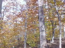
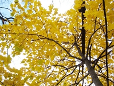
Pennsylvania is known for great fall foliage. There is no better place to enjoy the autumn colors than on our wonderful trails. Here are a few hikes in the area that feature some great views.
Hike to Pole Steeple - 6 miles, moderate. Pole Steeple is a rock outcropping northeast of Pine Grove Furnace State Park, near Gardners, PA. You start at the parking lot near the Furnace Stack and adjacent to the Appalachian Trail Museum. Find the white blazes for the Appalachian Trail and follow it northbound. You are going the right way if you pass the Fuller Lake swimming area and bath house within a few hundred yards. You are going the wrong way if you pass the Park Store and the Ironmasters Hostel. Proceed through the park on macadam and gravel trail. As you leave the park, near a sign kiosk, the AT turns right and begins to gradually climb up hill. As you reach the top of South Mountain, you'll see a sign for Pole Steeple and a blue blazed trail. Follow the blue blazes for about .2 mile until you reach the rock outcropping. Pole Steeple offers dramatic views of the Park and surrounding Michaux Forest. To return, you have two options. 1. Retrace your steps back to the Park. 2. About halfway back out on the blue blazed trail, before you reach the A.T., follow the blue blazes to your right. This is the Pole Steeple Trail. It takes you straight down the mountain to a gravel road and parking lot. Turn left and follow the gravel road for about a mile, and you will rejoin the A.T., which you follow back to where you started.
Hike To Flat Rock - 5 miles, out and back, strenuous in places. This hike starts in Col. Denning State Park, north of Newville, on the Cumberland - Perry County line. Start at the Parking lot across route 233 from the Doubling Gap Center Lodge. Follow the trail away from the road up the hill. As you reach a concrete water cistern, the trail becomes steep. It continues up steeply until you reach a plateau where several trails meet. Follow the signs for Flat Rock. After a flat stretch, it becomes moderately steep and somewhat rocky until you reach the top of Blue Mountain. You are rewarded by incredible views from a huge rock on top of the mountain that gives this hike its name. This is probably the most spectacular view of the Cumberland Valley, and especially good during fall foliage season. Retrace your steps to return.
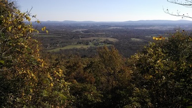
Hike To The A.T. Cumberland Valley Overlook - 6 miles, out and back, moderate, with one steady climb. Start at the Sherwood Drive Appalachian Trail parking lot. It is at 250 Sherwood Drive, Carlisle, PA, about .3 mile off Bernheisel Bridge Road. Head north on the Appalachian Trail, following the white blazes up the steps a short distance from the gravel lot. After about a mile, you'll follow the trail under Wertzville Road (PA Route 944). After another half mile, the AT becomes a steady climb up Blue Mountain. About three quarters of the way up is the Cumberland Valley Overlook. On a clear day, it provides a great view of the valley, from Carlisle to Newville to Camp Hill. Return by the same route.
Hike To The Susquehanna - Perry County Overlook - 7 miles, out and back, moderate, with one steady climb. Start at the Route 850 Appalachian Trail parking lot. It's in Perry county, near the junction of Route 850 and Millers Gap Road, about 5 miles east of Shermans Dale and 10 miles west of Marysville. From the parking lot, go north on the AT, crossing 850. After a mile or so of rolling to flat terrain, you'll start to climb Cove Mountain. The trail gets a bit rocky on top of the mountain. Soon you'll come to a clearing, with two views for the price of one. Look one way and you'll see the Susquehanna River. Look the other way, and you'll see beautiful woods and farm fields in Perry County. Return by the same route.
Hike To The Susquehanna - Perry County Overlook - 7 miles, out and back, moderate, with one steady climb. Start at the Route 850 Appalachian Trail parking lot. It's in Perry county, near the junction of Route 850 and Millers Gap Road, about 5 miles east of Shermans Dale and 10 miles west of Marysville. From the parking lot, go north on the AT, crossing 850. After a mile or so of rolling to flat terrain, you'll start to climb Cove Mountain. The trail gets a bit rocky on top of the mountain. Soon you'll come to a clearing, with two views for the price of one. Look one way and you'll see the Susquehanna River. Look the other way, and you'll see beautiful woods and farm fields in Perry County. Return by the same route.
Best Time To Go - Pennsylvania's Department of Conservation and Natural Resources (DCNR) keeps track of the progress of the leaves and publishes the latest information HERE. Check back often to get the latest information on the fall color. As of now, DCNR projects that the leaves will be at peak color in south-central Pennsylvania around the last week of October.